จังหวัดบูลูบุนดูคิน
หน้าตา
จังหวัดบูลูบุนดูคิน | |
|---|---|
จังหวัด | |
 | |
 ที่ตั้งในประเทศฟิลิปปินส์ | |
| ประเทศ | |
| เขต | เขตบริหารคอร์ดิลเยรา |
| ก่อตั้ง | ค.ศ. 1908 |
| เมืองหลัก | โบนโตก |
| การปกครอง | |
| • ประเภท | สภาจังหวัด |
| • ผู้ว่าราชการจังหวัด | Kathy Jyll Mayaen-Luis (Independent) |
| • รองผู้ว่าราชการจังหวัด | Boni Lacwasan (Independent) |
| พื้นที่[1] | |
| • ทั้งหมด | 2,157.38 ตร.กม. (832.97 ตร.ไมล์) |
| อันดับพื้นที่ | 58 จาก 81 |
| ความสูงจุดสูงสุด (ภูเขาซิงกากัลซา) | 2,717 เมตร (8,914 ฟุต) |
| ประชากร (ค.ศ. 2015)[2] | |
| • ทั้งหมด | 154,590 คน |
| • อันดับ | 76 จาก 81 |
| • ความหนาแน่น | 72 คน/ตร.กม. (190 คน/ตร.ไมล์) |
| • อันดับความหนาแน่น | 75 จาก 81 |
| เขตการปกครอง | |
| • นครอิสระ | 0 |
| • นคร | 0 |
| • เทศบาล | 10 |
| • บารังไกย์ | 144 |
| • Districts | Lone district of Mountain Province |
| เขตเวลา | UTC+8 (PHT) |
| รหัสไปรษณีย์ | 2616–2625 |
| ไอดีดี : รหัสโทรศัพท์ | +63 (0)74 |
| รหัส ISO 3166 | PH |
| ภาษา | |
| เว็บไซต์ | mountainprovince |
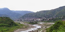
จังหวัดบูลูบุนดูคิน (ฟิลิปปินส์: Lalawigang Bulubundukin) เป็นจังหวัดที่ไม่มีทางออกสู่ทะเลในเขตบริหารคอร์ดิลเยรา เกาะลูซอน ประเทศฟิลิปปินส์ มีเมืองหลักคือโบนโตก จังหวัดนี้มักรู้จักกันในชื่อ จังหวัดเมาน์เทน เนื่องจากพื้นที่ส่วนใหญ่เป็นแนวเทือกเขาคอร์ดิลเยราเซนทรัล ซึ่งอยู่ทางตอนบนของเกาะลูซอน
จังหวัดเมาน์เทน เคยเป็นชื่อจังหวัดในอดีตที่ครอบคลุมพื้นที่จังหวัดในเขตบริหารคอร์ดิลเยราในปัจจุบัน อดีตจังหวัดแห่งนั้นจัดตั้งโดยคณะกรรมาธิการฟิลิปปินในปี ค.ศ. 1908[3][4][5] และถูกแยกออกในปี ค.ศ. 1966 ในชื่อจังหวัดบูลูบุนดูคิน, จังหวัดเบงเก็ต, จังหวัดคาลิงกา-อาปาเยา และจังหวัดอีฟูเกา[6][7][8]
จังหวัดนี้มีชื่อเสียงในด้านถ้ำมัมมี่ที่มีชื่อเสียง ซึ่งมีร่างที่ถูกทำมัมมี่อยู่จริง[6]
อ้างอิง
[แก้]- ↑ "List of Provinces". PSGC Interactive. Makati, Philippines: National Statistical Coordination Board. สืบค้นเมื่อ 23 December 2013.
- ↑ "สำเนาที่เก็บถาวร". คลังข้อมูลเก่าเก็บจากแหล่งเดิมเมื่อ 2017-10-10. สืบค้นเมื่อ 2018-03-28.
- ↑ Worcester, Dean C.; Philippine Commission (1908). Seventh Annual Report of the Secretary of the Interior to the Philippine Commission for the Fiscal Year Ended June 30, 1908 (Digitized by Google on 23 Nov 2005 (Original file from the University of Michigan)). Manila: U.S. Government Printing Office. pp. 17–19. สืบค้นเมื่อ 2 January 2015.
- ↑ Keesing, Felix Maxwell; Keesing, Marie Margaret; Keesing, Marie Martin; Institute of Pacific Relations (contributor); International Research Committee (contributor) (1934). Taming Philippine Headhunters: A Study of Government and of Cultural Change in Northern Luzon. Stanford University Press. p. 69. ISBN 9780804721103. สืบค้นเมื่อ 2 January 2015.
- ↑ Ingles, Raul Rafael (2008). 1908 :The Way it Really was : Historical Journal for the UP Centennial, 1908-2008. Diliman, Quezon City: University of the Philippines Press. p. 339. ISBN 9789715425803. สืบค้นเมื่อ 22 October 2014.
- ↑ 6.0 6.1 Lancion, Conrado M. Jr.; de Guzman, Rey (cartography) (1995). "The Provinces". Fast Facts about Philippine Provinces (The 2000 Millenium ed.). Makati, Metro Manila: Tahanan Books. pp. 108–109. ISBN 971-630-037-9. สืบค้นเมื่อ 16 January 2015.
- ↑ "Natural Attractions found in Atok". Province of Benguet. สืบค้นเมื่อ 13 August 2013.
- ↑ "Republic Act No. 4695: An Act Creating the Provinces of Benguet, Mountain Province, Ifugao and Kalinga-Apayao". Chan Robles Virtual Law Library. สืบค้นเมื่อ 22 October 2014.
แหล่งข้อมูลอื่น
[แก้] วิกิมีเดียคอมมอนส์มีสื่อเกี่ยวกับ จังหวัดบูลูบุนดูคิน
 ดูข้อมูลทางภูมิศาสตร์ที่เกี่ยวข้องกับ จังหวัดบูลูบุนดูคิน ที่โอเพินสตรีตแมป


