แม่แบบ:กล่องข้อมูล ไฟป่า
หน้าตา
| แม่แบบนี้ใช้ลูอา |
การใช้งาน
[แก้]Individual fire
[แก้]| {{{title}}} | |
|---|---|
| [[File:{{{image}}}|{{{image_size}}}|alt={{{alt}}}|{{{alt}}}]] {{{caption}}} | |
| สถานที่ | {{{location}}} |
| พิกัดภูมิศาสตร์ | 0°N 0°E / 0°N 0°E |
| สถิติ{{{reference}}} | |
| Cost | {{{cost}}} |
| วันที่ | {{{date}}} {{{time}}} {{{time-begin}}}–{{{time-end}}} ({{{timezone}}}) |
| พื้นที่ที่ถูกเผา | {{{area}}} |
| สาเหตุ | {{{cause}}} |
| การใช้ที่ดิน | {{{landuse}}} |
| อาคารถูกทำลาย | {{{buildings}}} |
| ผู้เสียชีวิต | {{{fatalities}}} |
| สัตว์สูญหาย | {{{livestock}}} |
| ผู้บาดเจ็บ | {{{injuries}}} |
| ผู้หายสาบสูญ | {{{missing}}} |
| อพยพ | {{{evacuated}}} |
| ผู้กระทำผิด | {{{perps}}} |
| เหตุผล | {{{motive}}} |
| แผนที่ | |
| [[File:{{{image_map}}}|200px|alt={{{image_map_alt}}}|upright=1|{{{image_map_caption}}}]] {{{image_map_caption}}} | |
{{Infobox wildfire
| title               =
| image               =
| image_size          =
| alt                 =
| caption             =
| location            =
| coordinates         =
| reference           = <!-- or: | references = -->
| cost                =
| date                =
| time                =
| time-begin          =
| time-end            =
| timezone            =
| area                =
| acres               =
| cause               =
| landuse             =
| buildings           =
| structures          =
| livestock           =
| injuries            =
| fatalities          =
| missing             =
| evacuated           =
| perps               =
| motive              =
| image_map           =
| image_map_alt       =
| image_map_caption   = <!-- or: | name =  -->
| pushpin_map         =
| pushpin_map_alt     =
| pushpin_map_caption =
}}
Delete or comment-out the time, time-begin, time-end and timezone parameters for a multi-day wildfire after the fire is extinguished, as leaving those parameters just causes the template to become cluttered. If the start time and end time are significant, these may instead be described in the body of the article.
Season
[แก้]| {{{title}}} | |
|---|---|
| [[File:{{{image}}}|{{{image_size}}}|alt={{{alt}}}|{{{alt}}}]] {{{caption}}} | |
| สถิติ{{{reference}}} | |
| Total fires | {{{total_fires}}} |
| พื้นที่ทั้งหมด | {{{total_area}}} |
| Cost | {{{cost}}} |
| พื้นที่ที่ถูกเผา | {{{acres}}} |
| อาคารถูกทำลาย | {{{structures}}} |
| ผู้เสียชีวิต | {{{fatalities}}} |
| ผู้บาดเจ็บ | {{{injuries}}} |
| ฤดูกาล | |
← [[{{{prev}}}|ฤดูกาลก่อนหน้า]]
[[{{{next}}}|ฤดูกาลถัดไป]] → | |
{{Infobox wildfire
| title       =
| image       =
| image_size  =
| alt         =
| caption     =
| reference   = <!-- or: | references = -->
| total_fires =
| total_area  =
| cost        =
| acres       =
| structures  =
| injuries    =
| fatalities  =
| is_season   =
| prev        =
| year        =
| season_name =
| next        =
}}
Examples
[แก้]Individual fire
[แก้]| Jesusita Fire | |
|---|---|
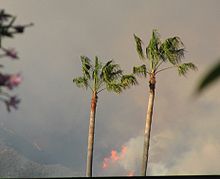
 Jesusita Fire, May 7, 2009, climbing the Santa Ynez Mountains behind Santa Barbara. | |
| สถานที่ | Santa Barbara, California, United States |
| พิกัดภูมิศาสตร์ | 34°27′00″N 119°43′01″W / 34.45°N 119.717°W |
| สถิติ[1] | |
| Cost | $12 million |
| วันที่ | May 5, 2009 — May 18, 2009 |
| พื้นที่ที่ถูกเผา | 8,733 เอเคอร์ (3,534 เฮกตาร์) |
| สาเหตุ | Sparks off of trail clearing equipment |
| การใช้ที่ดิน | Residential; Open space |
| อาคารถูกทำลาย |
|
| ผู้เสียชีวิต |
|
| ผู้บาดเจ็บ |
|
| อพยพ | 2,456 |
| ผู้กระทำผิด | John Smith |
| เหตุผล | Accidental |
| แผนที่ | |
| ข้อผิดพลาด Lua ใน มอดูล:Location_map บรรทัดที่ 522: Unable to find the specified location map definition: "Module:Location map/data/USA California Southern" does not exist | |
{{Infobox wildfire
| title               = Jesusita Fire
| image               = JesusitaFire1.jpg
| caption             = Jesusita Fire, May 7, 2009, climbing the [[Santa Ynez Mountains]] behind Santa Barbara.
| location            = [[Santa Barbara, California|Santa Barbara]], [[California]], [[United States]]
| coordinates         = {{Coord|34.45|-119.717|region:US-CA|display=inline,title}}
| reference           = <ref name=CDF>{{cite web|title=Jesusita Fire|url=http://cdfdata.fire.ca.gov/incidents/incidents_details_info?incident_id=310|website=[[California Department of Forestry and Fire Protection|CAL FIRE]]|access-date=20 August 2015}}</ref>
| cost                = $12 million
| date                = May 5, 2009 — May 18, 2009
| area                = {{convert|8733|acre|ha|0}}
| cause               = Sparks off of trail clearing equipment
| landuse             = Residential; Open space
| buildings           = {{Unbulleted list|80 homes|79 outbuildings|1 commercial property}}
| injuries            = {{Unbulleted list|1 civilians|2 firefighters}}
| fatalities          = {{Unbulleted list|3 civilians|4 firefighters}}
| evacuated           = 2,456
| perps               = John Smith
| motive              = Accidental
| pushpin_map         = USA California Southern
| pushpin_map_caption = Location of Jesusita Fire in Southern California
}}
- References
- ↑ "Jesusita Fire". CAL FIRE. สืบค้นเมื่อ 20 August 2015.
Season
[แก้]| 2014 California wildfires | |
|---|---|
| สถิติ | |
| Total fires | 1,234 |
| พื้นที่ทั้งหมด | 123,456 เอเคอร์ (49,961 เฮกตาร์) |
| Cost | $20 million |
| ผู้เสียชีวิต |
|
| ผู้บาดเจ็บ |
|
| ฤดูกาล | |
← 2013
2015 → | |
{{Infobox wildfire
| title       = 2014 California wildfires
| image       =
| alt         =
| caption     =
| total_fires = 1,234
| total_area  = {{convert|123456|acre|ha|0}}
| cost        = $20 million
| injuries    = {{Unbulleted list|12 civilians|15 firefighters}}
| fatalities  = {{Unbulleted list|12 civilians|15 firefighters}}
| is_season   = yes
| year        = 2014
| season_name = California wildfires
}}
| คู่มือการใช้งานที่ปรากฏด้านบนนี้ดึงมาจาก แม่แบบ:กล่องข้อมูล ไฟป่า/doc (แก้ | ประวัติ) ผู้เขียนสามารถทำการทดลองได้ที่กระบะทราย (สร้าง | คัดลอก) และชุดทดสอบ (สร้าง) ของแม่แบบนี้ โปรดเพิ่มหมวดหมู่ไปที่หน้าย่อย /doc หน้าย่อยของแม่แบบนี้ |

