แม่น้ำเฟรเซอร์
หน้าตา
| แม่น้ำเฟรเซอร์ | |
| Staulo [1], Lhtako [2], Tacoutche Tesse[3], Sto:lo | |
The Fraser River, from the grounds of Westminster Abbey, above Hatzic in Mission, British Columbia, looking upstream (E).
| |
| ประเทศ | Canada |
|---|---|
| Province | British Columbia |
| ต้นกำเนิด | Fraser Pass |
| - ตำแหน่ง | Rocky Mountains, Mount Robson Provincial Park, British Columbia, Canada |
| - พิกัด | 52°31.1′N 118°19.0′W / 52.5183°N 118.3167°W |
| ปากแม่น้ำ | Fraser River Delta |
| - ตำแหน่ง | Strait of Georgia, Vancouver, British Columbia, Canada |
| - ระดับ | |
| - พิกัด | 49°7′N 123°11.5′W / 49.117°N 123.1917°W |
| ความยาว | 1,375 km (854 mi) [4] |
| พื้นที่ลุ่มน้ำ | 220,000 ตร.กม. (84,942 ตร.ไมล์) |
| การไหล | for mouth (average and min); max at Hope |
| - เฉลี่ย | 3,475 m3/s (122,718 cu ft/s) [5] |
| - สูงสุด | 17,000 m3/s (600,349 cu ft/s) |
| - ต่ำสุด | 575 m3/s (20,306 cu ft/s) |
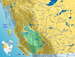
แม่น้ำเฟรเซอร์ (อังกฤษ: Fraser River) เป็นแม่น้ำสายยาวที่สุดในรัฐบริติชโคลัมเบีย ประเทศแคนาดา ต้นน้ำเกิดจากเทือกเขาร็อกกี ไหลไปทางตะวันตกเฉียงเหนือ ระหว่างเทือกเขาร็อกกีกับทิวเขาแคริบู ใกล้เขตแดนสหรัฐอเมริกา และไหลไปทางตะวันตก ตัดผ่านเทือกเขาโคสต์ทำให้เกิดหุบผาชันเป็นแนวยาว แล้วไหลลงสู่ช่องแคบจอร์เจียทางตอนใต้ของเมืองแวนคูเวอร์ แม่น้ำมีความยาว 1,375 กิโลเมตร เป็นแม่น้ำยาวเป็นอันดับ 10 ของแคนาดา[6] แม่น้ำสายนี้อเล็กซานเดอร์ แมกเคนซี เป็นผู้ค้นพบใน ค.ศ. 1793 ต่อมาในปี ค.ศ. 1808 ไซมอน เฟรเซอร์ได้เดินเรือสำรวจถึงบริเวณปากแม่น้ำ
อ้างอิง
[แก้]- ↑ Salishan languages and Chinook Jargon. The Halkomelem form is Sto:lo, used as the name of the people of the Fraser Valley stretch of the river. "Staulo" is the anglicization used in the Kamloops Wawa lexicon of the Chinook Jargon
- ↑ Carrier language. Lhtako is also used to mean the Dakelh people of the Quesnel/North Cariboo area
- ↑ Indigenous name recorded by Alexander Mackenzie on expedition to find Columbia River’s headwaters; circa 18-?
- ↑ "Lower Fraser River Hydraulic Model - Summary of Results" (PDF). November 14, 2006. คลังข้อมูลเก่าเก็บจากแหล่งเดิม (PDF)เมื่อ 2012-02-27. สืบค้นเมื่อ 2009-10-11.
- ↑ Ambient Water Quality Assessment and Objectives for the Fraser River sub-basin from Kanaka Creek to the Mouth เก็บถาวร 2016-03-04 ที่ เวย์แบ็กแมชชีน, BC Ministry of Environment
- ↑ Canadian Global Almanac. John Wiley and Sons. 2004


