มอดูล:Location map/data/Indonesia Sumatra North/doc
หน้าตา
| นี่คือหน้าคู่มือการใช้งานของ มอดูล:Location map/data/Indonesia Sumatra North ใช้ในการเขียนคำอธิบายแม่แบบหรือมอดูลและใส่หมวดหมู่ ส่วนลิงก์ข้ามภาษาโปรดใช้วิกิสนเทศ |
| name | สุมาตราเหนือ | |||
|---|---|---|---|---|
| border coordinates | ||||
| 6.02 | ||||
| 94.99 | ←↕→ | 101.96 | ||
| 0.35 | ||||
| map center | 3°11′06″N 98°28′30″E / 3.185°N 98.475°E | |||
| image | Location map Northern Sumatra.png
| |||

| ||||
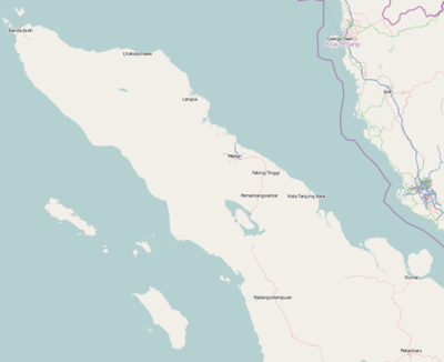
มอดูล:Location map/data/Indonesia Sumatra North คือมอดูลนิยามแผนที่แบบ equirectangular projection ของสุมาตราเหนือ เพื่อใช้กำหนดตำแหน่งบนแผนที่ค่าเริ่มต้นหรือแผนที่ใกล้เคียงด้วยสัญลักษณ์หรือข้อความโดยใช้ค่าพิกัดละติจูดและลองจิจูด
การใช้งาน
เมื่อกำหนดค่าพารามิเตอร์ "Indonesia Sumatra North" ลงในแม่แบบต่าง ๆ ด้านล่าง จะใช้ค่านิยามจากมอดูลนี้
{{Location map|Indonesia Sumatra North |...}}{{Location map many|Indonesia Sumatra North |...}}{{Location map+|Indonesia Sumatra North |...}}{{Location map~|Indonesia Sumatra North |...}}
ค่านิยาม
name = สุมาตราเหนือ- ชื่อที่ใช้ในคำอธิบายแผนที่ค่าเริ่มต้น (default map)
image = Location map Northern Sumatra.png- ภาพแผนที่ค่าเริ่มต้น ไม่ต้องใส่ "Image:" หรือ "File:" (หรือ "ภาพ:" หรือ "ไฟล์:")
top = 6.02- ค่าละติจูดของตำแหน่งขอบบนสุดของแผนที่ในค่าทศนิยม (decimal degrees)
bottom = 0.35- ค่าละติจูดของตำแหน่งขอบล่างสุดของแผนที่ในค่าทศนิยม
left = 94.99- ค่าลองจิจูดของตำแหน่งขอบซ้ายสุดของแผนที่ในค่าทศนิยม
right = 101.96- ค่าลองจิจูดของตำแหน่งขอบขวาสุดของแผนที่ในค่าทศนิยม
ความแม่นยำ
ลองจิจูด: ค่านิยามแผนที่นี้มีขนาดจากทิศตะวันตกถึงตะวันออก 6.97 องศา
- ภาพขนาดความกว้าง (width) 200 พิกเซล เทียบอัตราส่วนได้ 0.0349 องศาต่อพิกเซล
- ภาพขนาดความกว้าง (width) 1,000 พิกเซล เทียบอัตราส่วนได้ 0.007 องศาต่อพิกเซล
ละติจูด: ค่านิยามแผนที่นี้มีขนาดจากทิศเหนือถึงใต้ 5.67 องศา
- ภาพขนาดความสูง (height) 200 พิกเซล เทียบอัตราส่วนได้ 0.0284 องศาต่อพิกเซล
- ภาพขนาดความสูง (height) 1,000 พิกเซล เทียบอัตราส่วนได้ 0.0057 องศาต่อพิกเซล
ดูเพิ่ม
- แม่แบบตำแหน่งบนแผนที่
- แม่แบบ:Location map แสดงสัญลักษณ์และข้อความบนแผนที่ได้ 1 ตำแหน่งโดยใช้ค่าละติจูดและลองจิจูด
- แม่แบบ:Location map many แสดงสัญลักษณ์และข้อความบนแผนที่ได้สูงสุด 9 ตำแหน่ง
- แม่แบบ:Location map+ แสดงสัญลักษณ์และข้อความบนแผนที่ได้ไม่จำกัดจำนวน
- การสร้างค่านิยามแผนที่ใหม่
- แม่แบบ:Location map/Creating a new map definition
- แม่แบบ:Location map/doc/Converting map definition templates to modules
- แม่แบบกล่องข้อมูล (Infobox template) ที่ใช้แม่แบบตำแหน่งบนแผนที่
List
- Template:Infobox aerial lift line
- Template:Infobox airport — alternative map support: relief (via pushpin_relief) and AlternativeMap (via pushpin_image)
- Template:Infobox ancient site — alternative map support: relief
- Template:Infobox artwork
- Template:Infobox Australia state or territory
- Template:Infobox Australian road
- Template:Infobox body of water
- Template:Infobox bridge
- Template:Infobox building — alternative map support: relief
- Template:Infobox business park
- Template:Infobox casino
- Template:Infobox castrum — alternative map support: relief (via map_relief)
- Template:Infobox cave — alternative map support: relief
- Template:Infobox cemetery
- Template:Infobox civil conflict
- Template:Infobox climbing area
- Template:Infobox climbing route — alternative map support: relief
- Template:Infobox church — alternative map support: relief
- Template:Infobox concentration camp
- Template:Infobox convention center
- Template:Infobox cycling championship
- Template:Infobox dam — alternative map support: relief
- Template:Infobox desalination plant
- Template:Infobox disputed islands
- Template:Infobox earthquakes in date
- Template:Infobox Egyptian tomb
- Template:Infobox factory
- Template:Infobox fault
- Template:Infobox forest — alternative map support: relief
- Template:Infobox former Arab villages in Palestine
- Template:Infobox glacier — alternative map support: relief (displays relief image unless map_relief=0)
- Template:Infobox golf facility — alternative map support: relief
- Template:Infobox Hindu temple
- Template:Infobox historic site — alternative map support: relief (via map_relief)
- Template:Infobox holocaust event
- Template:Infobox hospital — alternative map support: relief
- Template:Infobox hut — alternative map support: relief
- Template:Infobox Icelandic municipality
- Template:Infobox islands — alternative map support: relief
- Template:Infobox landform
- Template:Infobox lighthouse — alternative map support: relief
- Template:Infobox Manchester Metrolink station
- Template:Infobox military conflict — alternative map support: relief (via map_relief)
- Template:Infobox military installation — alternative map support: relief (via map_relief)
- Template:Infobox military operation
- Template:Infobox mill building
- Template:Infobox mine
- Template:Infobox mining
- Template:Infobox monastery
- Template:Infobox monument
- Template:Infobox motorway services
- Template:Infobox mountain — alternative map support: relief (displays relief image unless map_relief=0)
- Template:Infobox mountain pass — alternative map support: relief (displays relief image unless map_relief=0)
- Template:Infobox museum — alternative map support: relief (via map_relief)
- Template:Infobox New York City Subway station
- Template:Infobox New Zealand suburbs
- Template:Infobox observatory
- Template:Infobox oil field — alternative map support: relief
- Template:Infobox oil refinery — alternative map support: relief
- Template:Infobox park — alternative map support: relief
- Template:Infobox port
- Template:Infobox power station — alternative map support: relief
- Template:Infobox prison
- Template:Infobox protected area — alternative map support: relief
- Template:Infobox pyramid
- Template:Infobox reactor
- Template:Infobox religious building — alternative map support: relief
- Template:Infobox residential college
- Template:Infobox restaurant
- Template:Infobox river
- Template:Infobox Russian inhabited locality
- Template:Infobox school
- Template:Infobox Scottish island
- Template:Infobox sedimentary basin
- Template:Infobox settlement — alternative map support: relief (via pushpin_relief) and AlternativeMap (via pushpin_image)
- Template:Infobox ski area
- Template:Infobox South African town
- Template:Infobox Spanish missions in the Americas
- Template:Infobox sports rivalry
- Template:Infobox spring — alternative map support: relief
- Template:Infobox station
- Template:Infobox street
- Template:Infobox superfund
- Template:Infobox terrestrial impact site
- Template:Infobox transmitter
- Template:Infobox tunnel
- Template:Infobox valley — alternative map support: relief
- Template:Infobox waterfall — alternative map support: relief
- Template:Infobox waterlock
- Template:Infobox UNESCO World Heritage Site — alternative map support: relief
- Template:Infobox university
- Template:Infobox urban feature
- Template:Infobox venue
- Template:Infobox wildfire
- Template:Infobox WorldScouting
การใช้งาน
{{#invoke:Location map/data/Indonesia Sumatra North|function_name}}
