เกาะนิวฟันด์แลนด์
 ภาพดาวเทียมของนิวฟันด์แลนด์ | |
 แผนที่นิวฟันด์แลนด์ | |
| ภูมิศาสตร์ | |
| ที่ตั้ง | มหาสมุทรแอตแลนติก |
| พิกัด | 49°00′N 56°00′W / 49.000°N 56.000°W |
| พื้นที่ | 108,860 ตารางกิโลเมตร (42,030 ตารางไมล์) |
| อันดับพื้นที่ | อันดับ 4 ในประเทศแคนาดา อันดับที่ 16 ทั่วโลก |
| ความยาวชายฝั่ง | 9,656 กม. (6000 ไมล์) |
| ระดับสูงสุด | 814 ม. (2671 ฟุต) |
| จุดสูงสุด | The Cabox |
| การปกครอง | |
ประเทศแคนาดา | |
| รัฐ | นิวฟันด์แลนด์และแลบราดอร์ |
| เมืองใหญ่สุด | เซนต์จอนส์ (ประชากร 200,600 คน) |
| ประชากรศาสตร์ | |
| ประชากร | 477,787 คน[3] (2016) |
| อันดับประชากร | 80 |
| ความหนาแน่น | 4.39/กม.2 (11.37/ตารางไมล์) |
| กลุ่มชาติพันธุ์ | อังกฤษ, ไอริช, สกอต, ฝรั่งเศส และ Mi'kmaq |
| ข้อมูลอื่น ๆ | |
| เขตเวลา | |
| • ฤดูร้อน (ออมแสง) | |
| แม่น้ำที่ยาวที่สุด: แม่น้ำเอ็กซ์พล็อยตส์ (246 กิโลเมตร (153 ไมล์))[4] | |
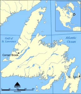
เกาะนิวฟันด์แลนด์ (อังกฤษ: Newfoundland Island) เป็นเกาะขนาดใหญ่ของประเทศแคนาดา อยู่นอกชายฝั่งทางทิศตะวันออกของอเมริกาเหนือ ในมหาสมุทรแอตแลนติก รวมกับแลบราดอร์บนผืนแผ่นดินใหญ่เป็นรัฐหนึ่งของแคนาดา เดิมใช้ชื่อรัฐว่ารัฐนิวฟันด์แลนด์ จนกระทั่ง ค.ศ. 2001 เปลี่ยนชื่อมาเป็นรัฐนิวฟันด์แลนด์และแลบราดอร์
เกาะนิวฟันด์แลนด์ (เดิมเรียกว่า เทอร์ราโนวา มาจากภาษาละติน มีความหมายว่า ดินแดนใหม่) มีนักเดินทางชาวไอซ์แลนด์ เลฟ เอริกสัน เดินทางมาถึงเกาะเมื่อศตวรรษที่ 11 เรียกเกาะนี้ว่า "วินแลนด์" ต่อมาจอห์น แคบอต (โจวานนี กาโบโต) ได้เดินทางมาภายใต้การสัญญาการทำงานของสมเด็จพระเจ้าเฮนรีที่ 7 แห่งอังกฤษ โดยได้เดินทางออกจากเมืองบริสทอลในปี ค.ศ. 1497 อังกฤษได้ประกาศกรรมสิทธิ์เหนือดินแดนนี้อย่างเป็นทางการเมื่อวันที่ 5 สิงหาคม ค.ศ. 1583 โดยเซอร์ฮัมฟรีย์ กิลเบิร์ต
เกาะมีพื้นที่ 108,860 ตร.กม. (42,031 ตร.ไมล์)[5] เป็นเกาะที่ใหญ่เป็นอันดับ 4 ของโลก เมืองหลวงของรัฐ เซนต์จอนส์ ตั้งอยู่ชายฝั่งตะวันออกเฉียงใต้ของเกาะ
ลักษณะภูมิประเทศส่วนใหญ่เป็นที่ราบสูง จุดสูงสุดอยู่ในภูเขาลองเรนจ์ สูง 814 ม. เกาะนี้มีรูปร่างคล้ายสามเหลี่ยม มีแหลมบอลด์อยู่ทางเหนือ แหลมเรซทางตะวันออกเฉียงใต้ และแหลมเรย์ทางตะวันตกเฉียงใต้ ชายฝั่งเว้าแหว่งมากโดยเฉพาะทางด้านตะวันออกและใต้ มีช่องแคบเบลล์ไอล์อยู่ระหว่างเกาะนี้กับผืนแผ่นดินใหญ่ มีเกาะจำนวนมากเรียงรายตามแนวชายฝั่ง เช่น เกาะเบลล์ไอล์ เกาะเกร เกาะเบลล์ และเกาะโฟโกทางตอนเหนือ หมู่เกาะแซง-ปีแยร์และมีเกอลงทางตอนใต้ (เป็นของฝรั่งเศส) แม่น้ำสายใหญ่สุดได้แก่ แม่น้ำเอกซ์ปลอยส์ แม่น้ำฮัมเบอร์ และแม่น้ำแกนเดอร์ ทะเลสาบที่สำคัญได้แก่ ทะเลสาบแกรนด์ ทะเลสาบเรดอินเดียนและทะเลสาบแกนเดอร์
อ้างอิง
[แก้]- ↑ Dekel, Jon (July 22, 2014). "Shaun Majumder brings Burlington, Newfoundland, to the world with Majumder Manor". National Post. คลังข้อมูลเก่าเก็บจากแหล่งเดิมเมื่อ July 29, 2014. สืบค้นเมื่อ July 29, 2014.
After all, it’s not every day the a famous native son of The Rock returns to its capital.
- ↑ Gunn, Malcolm (July 10, 2014). "The term "go anywhere" has been redefined with the redesign of a family favorite". Milwaukee Journal Sentinel. เก็บจากแหล่งเดิมเมื่อ July 29, 2014. สืบค้นเมื่อ July 29, 2014.
Canada's 10th province is called "The Rock" for good reason.
- ↑ จำนวนประชากรนี้คำนวณโดยหักจำนวนประชากรจาก Labrador (27,197), Little Bay Islands (71), Miles Cove (104), Port Anson (130), Lushes Bight-Beaumont-Beaumont North (168), Pilley's Island (294), Brighton (188), Triton (983), Division No. 8, Subd. D (10), Division No. 8, Subd. H (1,900), Cottlesville (271), Summerford (906), Division No. 8, Subd. I (216), Crow Head (177), Twillingate (2,196), Change Islands (208), Fogo Island (2,244), Greenspond (266), St. Brendan's (145), Division No. 7, Subd. L (1,232), Division No. 1, Subd. R (322), Wabana (2,146), Ramea (447) และ Dissemination Block 10090097012 (108) ออกจากรัฐนิวฟันด์แลนด์และแลบราดอร์ (519,716)
- ↑ "Atlas of Canada – Rivers". Natural Resources Canada. October 26, 2004. คลังข้อมูลเก่าเก็บจากแหล่งเดิมเมื่อ 2006-05-20. สืบค้นเมื่อ April 19, 2007.
- ↑ "Atlas of Canada, Islands". คลังข้อมูลเก่าเก็บจากแหล่งเดิมเมื่อ 2013-01-22. สืบค้นเมื่อ 2006-07-19.
อ่านเพิ่ม
[แก้]ประวัติศาสตร์สมัยใหม่
[แก้]- Sean T. Cadigan. Newfoundland and Labrador: A History (2009) search and text excerpt
- John Gimlette, Theatre of Fish, (Hutchinson, London, 2005). ISBN 0-09-179519-2
- Michael Harris. 1992. Rare Ambition: The Crosbies of Newfoundland. Penguin. ISBN 0-14-023220-6
- Wayne Johnston. 1999. The Colony Of Unrequited Dreams, Vintage Canada, Toronto, Ontario. ISBN 978-0-676-97215-3 (0-676-97215-2)
- Kevin Major, As Near To Heaven by Sea, (Toronto, 2001)
- Peter Neary. 1996. Newfoundland in the North Atlantic World, 1929–1949. McGill-Queen's University Press, Montreal, Quebec.
- Neary, Peter, and Patrick O'Flaherty. Part of the main : an illustrated history of Newfoundland and Labrador (1983) online free to borrow
- Rowe, Frederick William. A history of Newfoundland and Labrador (1980) online free to borrow
รายงานในอดีต
[แก้]- Barnes, Capt. William Morris. When Ships Were Ships (And Not Tin Pots), 1931. Available in digital format at Memorial University site here.
- Birkenhead, Lord. The Story of Newfoundland (2nd ed., 1920) 192pp edition[ลิงก์เสีย]
- Hatton, Joseph and Moses Harvey, Newfoundland: Its History and Present Condition, (London, 1883) complete text online* MacKay, R. A. Newfoundland: Economic, Diplomatic, and Strategic Studies, (1946) online edition เก็บถาวร 2009-03-27 ที่ เวย์แบ็กแมชชีน
- Millais, John Guille. The Newfoundland Guide Book, 1911: Including Labrador and St. Pierre (1911)? online edition; also reprinted 2009
- Moyles, Robert Gordon, ed. "Complaints is Many and Various, But the Odd Divil Likes It": Nineteenth Century Views of Newfoundland (1975).
- Pedley, Charles.History of Newfoundland, (London, 1863) complete text online
- Prowse, D. W., A History of Newfoundland (1895), current edition 2002, Portugal Cove, Newfoundland: Boulder Publications. complete text online
- Tocque, Philip. Newfoundland as It Was and Is, (London, 1878) complete text online
