
ไฟล์:Zealandia topography.jpg

ขนาดของตัวอย่างนี้: 516 × 600 พิกเซล ความละเอียดอื่น: 206 × 240 พิกเซล | 413 × 480 พิกเซล | 661 × 768 พิกเซล | 881 × 1,024 พิกเซล | 1,391 × 1,617 พิกเซล
ดูภาพที่มีความละเอียดสูงกว่า (1,391 × 1,617 พิกเซล, ขนาดไฟล์: 1.34 เมกะไบต์, ชนิดไมม์: image/jpeg)
| รูปภาพหรือไฟล์เสียงนี้ ต้นฉบับอยู่ที่ คอมมอนส์ รายละเอียดด้านล่าง เป็นข้อความที่แสดงผลจาก ไฟล์ต้นฉบับในคอมมอนส์
|
ความย่อ
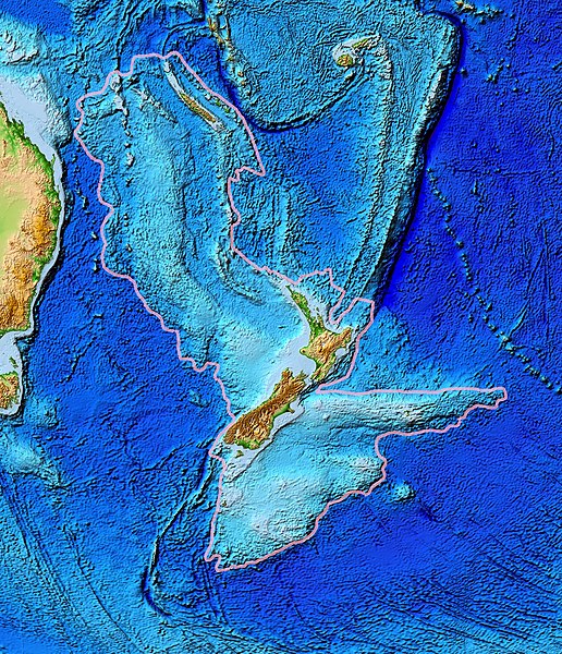
| คำอธิบาย | Topographical map of the Zealandia continent. |
| วันที่ | |
| แหล่งที่มา | Ultimate source: ETOPO2v2, a digital database of seafloor and land elevations. Actually cropped from Image:Pacific_elevation.jpg. |
| ผู้สร้างสรรค์ | World Data Center for Geophysics & Marine Geology (Boulder, CO), National Geophysical Data Center, NOAA |
| การอนุญาต (การใช้ไฟล์นี้ใหม่) |
NOAA, public domain |
| เวอร์ชันอื่น | Image:Pacific_elevation.jpg, here cropped to focus on Zealandia. |
การอนุญาตใช้สิทธิ
This image is in the public domain because it contains materials that originally came from the U.S. National Oceanic and Atmospheric Administration, taken or made as part of an employee's official duties.
|
ประวัติไฟล์
คลิกวันที่/เวลาเพื่อดูไฟล์ที่ปรากฏในขณะนั้น
| วันที่/เวลา | รูปย่อ | ขนาด | ผู้ใช้ | ความเห็น | |
|---|---|---|---|---|---|
| ปัจจุบัน | 20:24, 28 มีนาคม 2560 | | 1,391 × 1,617 (1.34 เมกะไบต์) | Bogomolov.PL | continent limits with pink |
| 08:44, 13 มีนาคม 2550 |  | 573 × 677 (143 กิโลไบต์) | Avenue | == Summary == {{Information |Description=Topographical map of the Zealandia continent. |Source=Source: [http://www.ngdc.noaa.gov/mgg/image/2minrelief.html]. Actually cropped from Image:Pacific_elevation.jpg. |Date=June 2006 |Permissio |
หน้าที่มีภาพนี้
หน้าต่อไปนี้ โยงมาที่ภาพนี้:
การใช้ไฟล์ข้ามโครงการ
วิกิอื่นต่อไปนี้ใช้ไฟล์นี้:
- การใช้บน af.wikipedia.org
- การใช้บน ang.wikipedia.org
- การใช้บน ar.wikipedia.org
- การใช้บน ast.wikipedia.org
- การใช้บน az.wikipedia.org
- การใช้บน bg.wikipedia.org
- การใช้บน bn.wikipedia.org
- การใช้บน ca.wikipedia.org
- การใช้บน el.wikipedia.org
- การใช้บน en.wikipedia.org
- การใช้บน eo.wikipedia.org
- การใช้บน es.wikipedia.org
- การใช้บน et.wikipedia.org
- การใช้บน eu.wikipedia.org
- การใช้บน fa.wikipedia.org
- การใช้บน fi.wikipedia.org
- การใช้บน fr.wikipedia.org
- การใช้บน gl.wikipedia.org
- การใช้บน he.wikipedia.org
- การใช้บน hi.wikipedia.org
- การใช้บน hr.wikipedia.org
- การใช้บน hu.wikipedia.org
- การใช้บน hy.wikipedia.org
- การใช้บน ia.wikipedia.org
- การใช้บน id.wikipedia.org
- การใช้บน incubator.wikimedia.org
- การใช้บน is.wikipedia.org
- การใช้บน it.wikipedia.org
- การใช้บน ja.wikipedia.org
- การใช้บน ka.wikipedia.org
ดูการใช้ข้ามโครงการเพิ่มเติมของไฟล์นี้