
ไฟล์:Un-myanmar.png
ดูภาพที่มีความละเอียดสูงกว่า (2,366 × 3,092 พิกเซล, ขนาดไฟล์: 1.83 เมกะไบต์, ชนิดไมม์: image/png)
| รูปภาพหรือไฟล์เสียงนี้ ต้นฉบับอยู่ที่ คอมมอนส์ รายละเอียดด้านล่าง เป็นข้อความที่แสดงผลจาก ไฟล์ต้นฉบับในคอมมอนส์
|
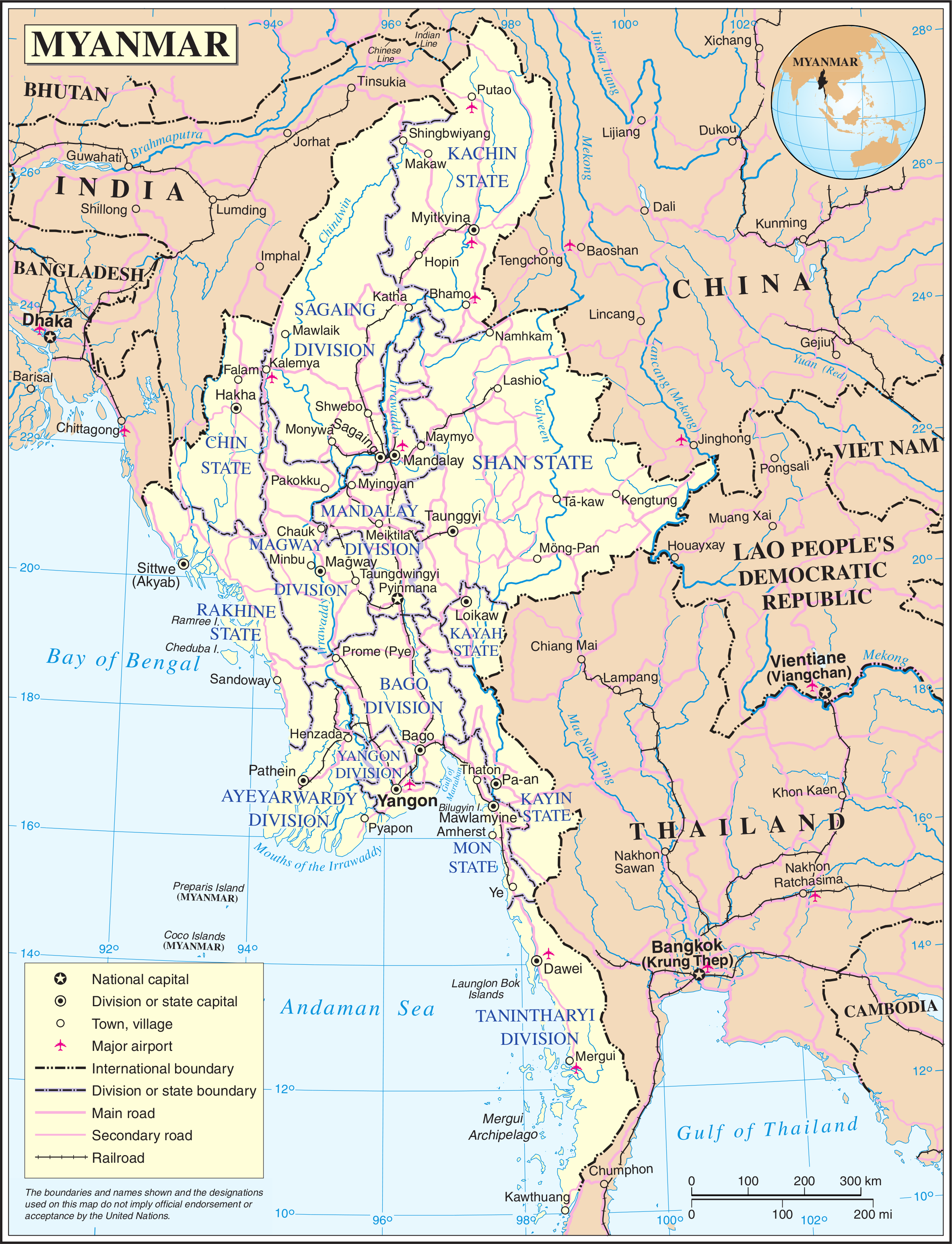
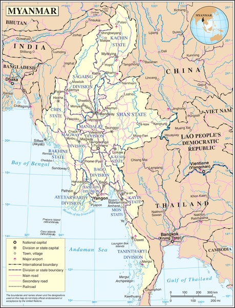
Map of Myanmar. Based on the UN map, but the location capital has been updated by me (the original uploader).
| This image is a map derived from a United Nations map.
Unless stated otherwise, UN maps are to be considered in the public domain. This applies worldwide. UN maps are, in principle, open source material and you can use them in your work or for making your own map. UN requests however that you delete the UN name, logo and reference number upon any modification to the map. Content of your map will be your responsibility. You can state in your publication, if you wish, something like: based on UN map … (map name, map number, revision number and date). See: Geospatial Information Section. And: Geospatial, location data for a better world. |
 |
ประวัติไฟล์
คลิกวันที่/เวลาเพื่อดูไฟล์ที่ปรากฏในขณะนั้น
| วันที่/เวลา | รูปย่อ | ขนาด | ผู้ใช้ | ความเห็น | |
|---|---|---|---|---|---|
| ปัจจุบัน | 04:11, 14 พฤษภาคม 2551 | | 2,366 × 3,092 (1.83 เมกะไบต์) | Mahahahaneapneap | Compressed |
| 08:36, 24 ตุลาคม 2550 |  | 2,366 × 3,092 (2.42 เมกะไบต์) | Jeroen | Map of Myanmar. Based on the UN map, but the location capital has been updated by me (the original uploader). {{UN map}} Category:Maps of Myanmar |
หน้าที่มีภาพนี้
หน้าต่อไปนี้ โยงมาที่ภาพนี้:
การใช้ไฟล์ข้ามโครงการ
วิกิอื่นต่อไปนี้ใช้ไฟล์นี้:
- การใช้บน az.wikipedia.org
- การใช้บน bn.wikipedia.org
- การใช้บน en.wikipedia.org
- การใช้บน fi.wikipedia.org
- การใช้บน fr.wikipedia.org
- การใช้บน gl.wikipedia.org
- การใช้บน kg.wikipedia.org
- การใช้บน pl.wiktionary.org
- การใช้บน shn.wikipedia.org
- การใช้บน simple.wikipedia.org
- การใช้บน si.wikipedia.org
- การใช้บน sl.wikipedia.org
- การใช้บน uk.wikipedia.org
- การใช้บน zh.wikipedia.org