
ไฟล์:Texel.jpg
ไม่มีภาพที่มีรายละเอียดสูงกว่านี้
Texel.jpg (800 × 600 พิกเซล, ขนาดไฟล์: 44 กิโลไบต์, ชนิดไมม์: image/jpeg)
| รูปภาพหรือไฟล์เสียงนี้ ต้นฉบับอยู่ที่ คอมมอนส์ รายละเอียดด้านล่าง เป็นข้อความที่แสดงผลจาก ไฟล์ต้นฉบับในคอมมอนส์
|
ความย่อ
| คำอธิบาย |
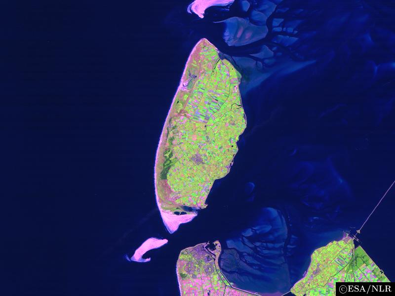
en:False colour en:satellite en:image of the en:island of en:Texel and its surroundings. The image was made by NLR and ESA.NLR and ESA are cited as its source. To the south of the island, part of the en:mainland of the Dutch en:province of en:North Holland can be seen, including the en:city of en:Den Helder (bottom center) and the former island of en:Wieringen (bottom right). Further features include the sand bar of en:Noorderhaaks to the southwest of Texel; the southernmost part of the neighbouring island of en:Vlieland (top center); the en:Afsluitdijk en:dam, which connects North Holland to en:Friesland (center right), the en:Wadden Sea, east of Texel; and the en:North Sea (west of Texel). |
| วันที่ | 23 สิงหาคม พ.ศ. 2547 (original upload date) |
| แหล่งที่มา | นำเข้าจาก en.wikipedia มายังคอมมอนส์ |
| ผู้สร้างสรรค์ | The original uploader was Cwoyte ที่ วิกิพีเดียภาษาอังกฤษ. |
การอนุญาตใช้สิทธิ

|
ผู้ถือลิขสิทธิ์ของไฟล์นี้ อนุญาตให้นำไฟล์นี้ไปใช้ได้ในทุกวัตถุประสงค์ รวมไปถึงการทำซ้ำ การนำไฟล์นี้ไปใช้ในการสร้างไฟล์ใหม่ การใช้เพื่อการค้า และการใช้อื่น ๆ โดยมีเงื่อนไขว่า ต้องระบุชื่อผู้ถือลิขสิทธิ์ของไฟล์นี้อย่างเหมาะสมเมื่อนำไฟล์นี้ไปใช้ |
|
|
ปูมการอัปโหลดต้นฉบับ
The original description page was here. All following user names refer to en.wikipedia.
- 2004-08-23 09:49 Cwoyte 800×600×8 (45082 bytes) Satellite image of the island of Texel and its surroundings.
ประวัติไฟล์
คลิกวันที่/เวลาเพื่อดูไฟล์ที่ปรากฏในขณะนั้น
| วันที่/เวลา | รูปย่อ | ขนาด | ผู้ใช้ | ความเห็น | |
|---|---|---|---|---|---|
| ปัจจุบัน | 00:53, 22 พฤษภาคม 2550 | | 800 × 600 (44 กิโลไบต์) | Matanya (usurped) | {{Information |Description=en:False colour en:satellite en:image of the en:island of en:Texel and its surroundings. The image was made by [http://www.npoc.nl NLR] and [http://www.esa.int ESA].NLR and ESA are cited as its source. |
หน้าที่มีภาพนี้
หน้าต่อไปนี้ โยงมาที่ภาพนี้:
การใช้ไฟล์ข้ามโครงการ
วิกิอื่นต่อไปนี้ใช้ไฟล์นี้:
- การใช้บน br.wikipedia.org
- การใช้บน de.wiktionary.org
- การใช้บน fa.wikipedia.org
- การใช้บน fi.wikipedia.org
- การใช้บน he.wikipedia.org
- การใช้บน is.wikipedia.org
- การใช้บน ja.wikipedia.org
- การใช้บน ka.wikipedia.org
- การใช้บน ko.wikipedia.org
- การใช้บน nl.wikipedia.org
- การใช้บน vi.wikipedia.org
- การใช้บน www.wikidata.org
- การใช้บน zh.wikipedia.org