ข้ามไปเนื้อหา

ไฟล์:Song Dynasty Map.JPG

ไม่รองรับเนื้อหาของหน้าในภาษาอื่น
จากวิกิพีเดีย สารานุกรมเสรี

ดูภาพที่มีความละเอียดสูงกว่า(756 × 768 พิกเซล, ขนาดไฟล์: 436 กิโลไบต์, ชนิดไมม์: image/jpeg)

Wikimedia Commons logo รูปภาพหรือไฟล์เสียงนี้ ต้นฉบับอยู่ที่ คอมมอนส์ รายละเอียดด้านล่าง เป็นข้อความที่แสดงผลจาก ไฟล์ต้นฉบับในคอมมอนส์
คอมมอนส์เป็นเว็บไซต์ในโครงการสำหรับเก็บรวบรวมสื่อเสรี ที่ คุณสามารถช่วยได้

Info

คำอธิบาย

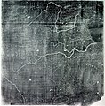
The Chinese Yu Ji Tu (Map of the Tracks of Yu the Great), a map carved into stone in the year 1137 during the Song Dynasty, located in the Stele Forest of modern-day Xian, China. Yu the Great refers to the Chinese deity described in the Chinese geographical work of the Yu Gong, a chapter of the Classic of History. Needham and Chavannes assert that the original map must have predated the 12th century.

The graduated scale of this gridded map is at 100 li (Chinese mile) squared for every representative square in the grid. The overall size of the map is 3 ft squared. The coastal outline is relatively firm and the precision of the network of river systems is incredibly accurate. The name of the geographers and cartographers who initially created the map are unknown. In the year 1142 a copy of the map was preserved at Zhenjiang in Jiangsu province by a certain Yu Chi, who was then a Prefectural Director of Studies. There is also mention of an earlier copy of about 1100 AD which itself was based on the Chang'an version. Needham asserts that the map was used primarily to instruct students while referring to sites described in the ancient Yu Gong chapter of the Classic of History.
วันที่ printing of a rubbing of a c. 1136 engraving of a c. 1100 map
แหล่งที่มา Joseph Needham's Science and Technology in China, Vol. 3: Mathematics and the Sciences of the Heavens and the Earth, Plate LXXXI and text description pp. 547–549, hardback edition
ผู้สร้างสรรค์ Unknown, photo by PericlesofAthens


Public domain

งานนี้เป็นสาธารณสมบัติ ในประเทศต้นกำเนิดและประเทศอื่น ๆ ที่ระยะเวลาการคุ้มครองลิขสิทธิ์น้อยกว่า 70 ปีหลังจากผู้สร้างสรรค์งานเสียชีวิต.


นอกจากนี้คุณอาจต้องเพิ่มป้ายสาธารณสมบัติในสหรัฐอเมริกา เพื่อระบุว่าเหตุใดงานนี้จึงเป็นสาธารณสมบัติในสหรัฐอเมริกา โปรดทราบว่าบางประเทศมีข้อกำหนดเรื่องการคุ้มครองลิขสิทธิ์นานกว่า 70 ปี เช่น เม็กซิโก 100 ปี, จาเมกา 95 ปี, โคลอมเบีย 80 ปี, กัวเตมาลาและซามัว 75 ปี ภาพนี้อาจไม่เป็นสาธารณสมบัติในประเทศเหล่านี้ซึ่ง งานลิขสิทธิ์อาจขยายไปในผลงานที่สร้างขึ้นโดยชาวฝรั่งเศสที่เสียชีวิตในประเทศฝรั่งเศสจากเหตุการณ์สงครามโลกครั้งที่สอง (ข้อมูลเพิ่มเติม), ชาวรัสเซียที่ทำหน้าที่ในแนวรบด้านตะวันออกในสงครามโลกครั้งที่สอง (หรือเรียกอย่างหนึ่งว่า สงครามต้อต้านความรักชาติอันยิ่งใหญ่ของรัสเซีย) และการพักฟื้นผู้เสียหายจากการถูกจองจำในสหภาพโซเวียต (ข้อมูลเพิ่มเติม)

Public domain ข้าพเจ้า ผู้ถือลิขสิทธิ์ในงานนี้ ขอมอบงานให้เป็นสาธารณสมบัติ ประกาศนี้มีผลทั่วโลก
ในบางประเทศ การกระทำดังกล่าวอาจไม่สามารถทำได้ตามกฎหมาย
ข้าพเจ้าอนุญาตให้ทุกคนมีสิทธิ์ในการใช้ไฟล์นี้ในทุกเหตุผลการใช้ โดยไม่มีมีเงื่อนไข เว้นแต่กฎหมายไม่อนุญาตให้ทำเช่นนั้น

คำบรรยายโดยย่อ

เพิ่มคำบรรยายทรรทัดเดียวเพื่อขยายความว่าไฟล์นี้มีอะไร

ไอเทมที่แสดงอยู่ในไฟล์นี้

ประกอบด้วย

ประวัติไฟล์

คลิกวันที่/เวลาเพื่อดูไฟล์ที่ปรากฏในขณะนั้น

วันที่/เวลารูปย่อขนาดผู้ใช้ความเห็น
ปัจจุบัน14:25, 3 สิงหาคม 2554รูปย่อสำหรับรุ่นเมื่อ 14:25, 3 สิงหาคม 2554756 × 768 (436 กิโลไบต์)Dragonet~commonswikibetter quality
17:32, 3 พฤศจิกายน 2550รูปย่อสำหรับรุ่นเมื่อ 17:32, 3 พฤศจิกายน 2550834 × 843 (89 กิโลไบต์)PericlesofAthens{{Information |Description=The Chinese ''Yu Ji Tu'' (Map of the Tracks of Yu the Great), a map carved into stone in the year 1137 during the Song Dynasty, located in the Stele Forest of modern-day Xian, China. Yu the Great refers to the Chinese deity desc

ไม่มีหน้าใดโยงมาที่ภาพนี้

การใช้ไฟล์ข้ามโครงการ

วิกิอื่นต่อไปนี้ใช้ไฟล์นี้:

ข้อมูลเกี่ยวกับภาพ