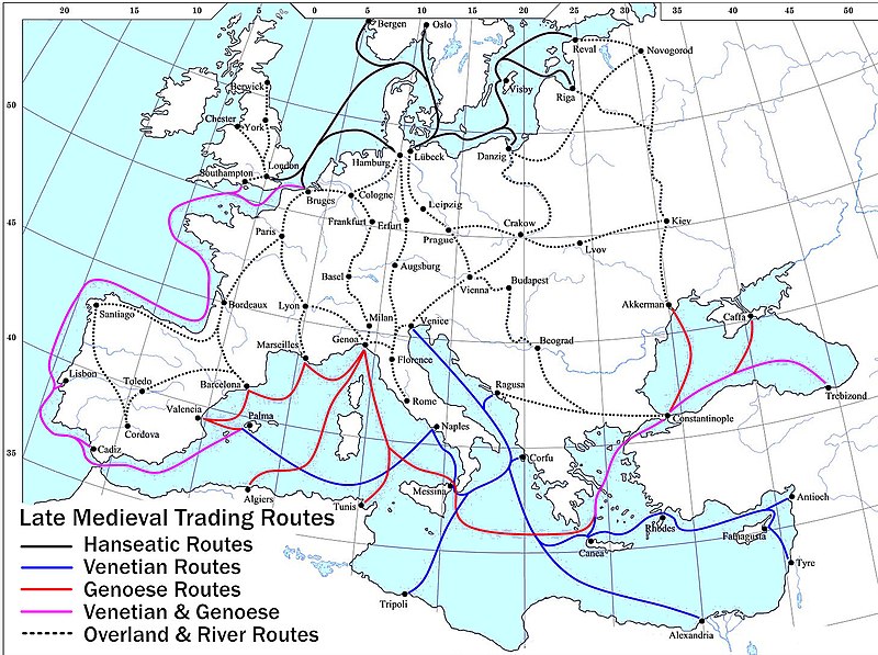
ไฟล์:Late Medieval Trade Routes.jpg
หน้าตา

ขนาดของตัวอย่างนี้: 800 × 597 พิกเซล ความละเอียดอื่น: 320 × 239 พิกเซล | 640 × 478 พิกเซล | 1,024 × 765 พิกเซล | 1,280 × 956 พิกเซล | 1,457 × 1,088 พิกเซล
ดูภาพที่มีความละเอียดสูงกว่า (1,457 × 1,088 พิกเซล, ขนาดไฟล์: 372 กิโลไบต์, ชนิดไมม์: image/jpeg)
ประวัติไฟล์
คลิกวันที่/เวลาเพื่อดูไฟล์ที่ปรากฏในขณะนั้น
| วันที่/เวลา | รูปย่อ | ขนาด | ผู้ใช้ | ความเห็น | |
|---|---|---|---|---|---|
| ปัจจุบัน | 03:46, 19 พฤษภาคม 2565 |  | 1,457 × 1,088 (372 กิโลไบต์) | Richard2s | Clearer key for map |
| 03:25, 24 มกราคม 2554 |  | 853 × 544 (453 กิโลไบต์) | Micsha~commonswiki | Includes map key on the map | |
| 22:55, 28 มีนาคม 2551 |  | 1,817 × 1,120 (487 กิโลไบต์) | Lampman | {{Information |Description=Map showing the main trade routes of late medieval Europe. The black lines show the routes of the Hanseatic League, the blue Venetian and the red Genoese routes. Purple lines are routes used by both the Venetians and the Genoese |
หน้าที่มีภาพนี้
หน้าต่อไปนี้ โยงมาที่ภาพนี้:
การใช้ไฟล์ข้ามโครงการ
วิกิอื่นต่อไปนี้ใช้ไฟล์นี้:
- การใช้บน ar.wikipedia.org
- การใช้บน be-tarask.wikipedia.org
- การใช้บน bg.wikipedia.org
- การใช้บน ca.wikipedia.org
- การใช้บน da.wikipedia.org
- การใช้บน el.wikipedia.org
- การใช้บน en.wikipedia.org
- Economics
- Trade
- Late Middle Ages
- Portal:Economics
- Wikipedia:Picture peer review/Archives/Jan-Mar 2008
- Wikipedia:Picture peer review/Late medieval trade routes
- Wikipedia:Valued picture candidates/January-2009
- Wikipedia:Valued picture candidates/Late Medieval Trade Routes
- Islamic influences on Western art
- การใช้บน es.wikipedia.org
- การใช้บน et.wikipedia.org
- การใช้บน fr.wikipedia.org
- การใช้บน he.wikipedia.org
- การใช้บน hy.wikipedia.org
- การใช้บน it.wikipedia.org
- การใช้บน ja.wikipedia.org
- การใช้บน mk.wikipedia.org
- การใช้บน nl.wikipedia.org
- การใช้บน pl.wikipedia.org
- การใช้บน pt.wikipedia.org
- การใช้บน rm.wikipedia.org
- การใช้บน sh.wikipedia.org
- การใช้บน sl.wikipedia.org
- การใช้บน sq.wikipedia.org
- การใช้บน uk.wikipedia.org
ดูการใช้ข้ามโครงการเพิ่มเติมของไฟล์นี้


