
ไฟล์:Fergana valley topo political.png
ไม่มีภาพที่มีรายละเอียดสูงกว่านี้
Fergana_valley_topo_political.png (375 × 178 พิกเซล, ขนาดไฟล์: 136 กิโลไบต์, ชนิดไมม์: image/png)
| รูปภาพหรือไฟล์เสียงนี้ ต้นฉบับอยู่ที่ คอมมอนส์ รายละเอียดด้านล่าง เป็นข้อความที่แสดงผลจาก ไฟล์ต้นฉบับในคอมมอนส์
|
| คำอธิบาย |
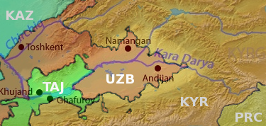
English: Map of the Fergana valley (highlighted) in Central Asia, national territories color coded, with shortened names, using boundaries from CIA 2001 Map File:Tajikistan_2001_CIA_map.jpg |
| วันที่ | (UTC) |
| แหล่งที่มา | |
| ผู้สร้างสรรค์ |
|
| ภาพนี้ ได้รับการปรับแต่งภาพ ซึ่งหมายความว่าจะได้รับการเปลี่ยนแปลงภาพต่างจากต้นฉบับ การปรับปรุง: Overlay national territories, highlight Fergana Valley. ต้นฉบับสามารถดูได้ที่นี่: Syrdaryamap.png. ปรับแต่งภาพโดย T L Miles.
|
ข้าพเจ้า ในฐานะผู้ถือลิขสิทธิ์ของภาพหรือสื่อนี้ อนุญาตให้ใช้ภาพหรือสื่อนี้ภายใต้เงื่อนไขต่อไปนี้
ไฟล์นี้อยู่ภายใต้สัญญาอนุญาตครีเอทีฟคอมมอนส์ รุ่นแสดงที่มา-อนุญาตแบบเดียวกัน 3.0 ต้นฉบับ, 2.5 ทั่วไป, 2.0 ทั่วไป และ 1.0 ทั่วไป
- คุณสามารถ:
- ที่จะแบ่งปัน – ที่จะทำสำเนา แจกจ่าย และส่งงานดังกล่าวต่อไป
- ที่จะเรียบเรียงใหม่ – ที่จะดัดแปลงงานดังกล่าว
- ภายใต้เงื่อนไขต่อไปนี้:
- แสดงที่มา – คุณต้องให้เกียรติเจ้าของงานอย่างเหมาะสม โดยเพิ่มลิงก์ไปยังสัญญาอนุญาต และระบุหากมีการเปลี่ยนแปลง คุณอาจทำเช่นนี้ได้ในรูปแบบใดก็ได้ตามควร แต่ต้องไม่ใช่ในลักษณะที่แนะว่าผู้ให้อนุญาตสนับสนุนคุณหรือการใช้งานของคุณ
- อนุญาตแบบเดียวกัน – หากคุณดัดแปลง เปลี่ยนรูป หรือต่อเติมงานนี้ คุณต้องใช้สัญญาอนุญาตแบบเดียวกันหรือแบบที่เหมือนกับสัญญาอนุญาตที่ใช้กับงานนี้เท่านั้น

|
อนุญาตให้คัดลอก แจกจ่ายและ/หรือดัดแปรเอกสารนี้ภายใต้เงื่อนไขของสัญญาอนุญาตเอกสารเสรีของกนู รุ่น 1.2 หรือรุ่นใด ๆ นับจากนี้ที่ออกโดยมูลนิธิซอฟต์แวร์เสรี โดยไม่มีส่วนใดห้ามแก้ไข ไม่มีข้อความปกหน้าและปกหลัง สำเนาของสัญญาอนุญาตรวมอยู่ในส่วนชื่อ สัญญาอนุญาตเอกสารเสรีของกนู |
คุณสามารถเลือกสัญญาอนุญาตดังกล่าวตามต้องการ
ปูมการอัปโหลดต้นฉบับ
This image is a derivative work of the following images:
- File:Syrdaryamap.png licensed with Cc-by-sa-3.0,2.5,2.0,1.0, GFDL
- 2010-02-07T03:04:09Z Shannon1 1101x866 (1580396 Bytes) {{Information |Description={{en|1=Map of the watershed of the Syr Darya in Central Asia, that drains to the Aral Sea.}} |Source=Background and river course data from http://www2.demis.nl/mapserver/mapper.asp |Author=Backgrou
Uploaded with derivativeFX
ประวัติไฟล์
คลิกวันที่/เวลาเพื่อดูไฟล์ที่ปรากฏในขณะนั้น
| วันที่/เวลา | รูปย่อ | ขนาด | ผู้ใช้ | ความเห็น | |
|---|---|---|---|---|---|
| ปัจจุบัน | 02:39, 15 มิถุนายน 2553 | | 375 × 178 (136 กิโลไบต์) | T L Miles | {{Information |Description={{en|1=Map of the watershed of the Syr Darya in Central Asia, that drains to the Aral Sea.}} |Source=*File:Syrdaryamap.png |Date=2010-06-14 19:38 (UTC) |Author=*File:Syrdaryamap.png: Background layer attributed to DE |
หน้าที่มีภาพนี้
หน้าต่อไปนี้ โยงมาที่ภาพนี้:
การใช้ไฟล์ข้ามโครงการ
วิกิอื่นต่อไปนี้ใช้ไฟล์นี้:
- การใช้บน da.wikipedia.org
- การใช้บน de.wikipedia.org
- การใช้บน de.wikivoyage.org
- การใช้บน en.wikipedia.org
- การใช้บน en.wikivoyage.org
- การใช้บน fa.wikipedia.org
- การใช้บน fi.wikipedia.org
- การใช้บน hi.wikipedia.org
- การใช้บน it.wikipedia.org
- การใช้บน ml.wikipedia.org
- การใช้บน mn.wikipedia.org
- การใช้บน ms.wikipedia.org
- การใช้บน pl.wikipedia.org
- การใช้บน ro.wikipedia.org
- การใช้บน sv.wikipedia.org
- การใช้บน ta.wikipedia.org
- การใช้บน te.wikipedia.org
- การใช้บน tl.wikipedia.org
- การใช้บน uk.wikipedia.org
- การใช้บน zh.wikivoyage.org