รัฐแมนิโทบา
หน้าตา
(เปลี่ยนทางจาก แมนิโทบา)
แมนิโทบา | |
|---|---|
| คำขวัญ: | |
| พิกัด: 55°00′00″N 97°00′00″W / 55.00000°N 97.00000°W | |
| ประเทศ | แคนาดา |
| เข้าร่วมสมาพันธ์ | 15 กรกฎาคม ค.ศ. 1870 (ลำดับที่ 5) |
| เมืองหลวง | วินนิเพก |
| เมืองใหญ่สุด | วินนิเพก |
| เขตมหานครใหญ่สุด | เขตเมืองหลวงวินนิเพก |
| การปกครอง | |
| • Lieutenant Governor | Janice Filmon |
| • นายกเทศมนตรี | Heather Stefanson (Progressive Conservative) |
| Legislature | Legislative Assembly of Manitoba |
| Federal representation | Parliament of Canada |
| สมาชิกสภาผู้แทนราษฎร | 14 จาก 338 (4.1%) |
| สมาชิกวุฒิสภา | 6 จาก 105 (5.7%) |
| พื้นที่ | |
| • ทั้งหมด | 649,950 ตร.กม. (250,950 ตร.ไมล์) |
| • พื้นดิน | 548,360 ตร.กม. (211,720 ตร.ไมล์) |
| • พื้นน้ำ | 101,593 ตร.กม. (39,225 ตร.ไมล์) 15.6% |
| อันดับพื้นที่ | อันดับที่ 8 |
| ร้อยละ 6.5 ของแคนาดา | |
| ประชากร | |
| • ทั้งหมด | 1,278,365 [1] คน |
| • ประมาณ (2021 Q1) | 1,380,935 [2] คน |
| • อันดับ | อันดับที่ 5 |
| • ความหนาแน่น | 2.33 คน/ตร.กม. (6.0 คน/ตร.ไมล์) |
| เดมะนิม | แมนิโทบัน |
| ภาษาราชการ | อังกฤษ[3] |
| ผลิตภัณฑ์มวลรวมในประเทศ | |
| • อันดับ | 6 |
| • ทั้งหมด (2015) | C$65.862 พันล้าน[4] |
| • ต่อหัว | C$50,820 (อันดับที่ 9) |
| เขตเวลา | UTC-06:00 (เขตเวลากลาง) |
| • ฤดูร้อน (เวลาออมแสง) | UTC-05:00 (เขตเวลากลาง DST) |
| * อันดับนับรวมทั้งรัฐและดินแดน | |
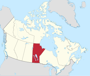
รัฐแมนิโทบา (อังกฤษ: Manitoba) เป็นรัฐบนที่ราบแพร์รีแคนาดา ของแคนาดามีพื้นที่ 649,950 ตร.กม. (250,900 ตร.ไมล์)[5] รัฐแมนิโทบาติดต่อกับรัฐออนแทรีโอทางตะวันออกและรัฐซัสแคตเชวันทางตะวันตก และดินแดนนูนาวุต ทางตอนเหนือ และติดกับรัฐนอร์ทดาโคตาและรัฐมินนิโซตา ของสหรัฐทางตอนใต้ รัฐแมนิโทบามีเส้นแนวชายฝั่งทะเลบริเวณอ่าวฮัดสันที่เชอร์ชิลล์
รัฐแมนิโทบามีประชากร 1,213,815 (โดยประมาณ จากข้อมูลปี 2009) มากกว่าครึ่งอยู่ในเมืองหลวง วินนิเพก (ประชากร 730,305 คน) ถือเป็นเมืองที่ใหญ่ที่สุดเป็นอันดับ 8 ของแคนาดา ในด้านจำนวนประชากร และเมืองปกครองด้วยตนเองที่ใหญ่ที่สุดเป็นอันดับ 7 ของแคนาดา
รัฐแมนิโทบาเข้าร่วมสมาพันธ์เมื่อวันที่ 15 กรกฎาคม ค.ศ. 1870
อ้างอิง
[แก้]- ↑ Statistics Canada. Population and dwelling counts, for Canada, provinces and territories, 2016 and 2011 censuses; 2 February 2017 [archived 4 May 2017].
- ↑ Statistics Canada. Estimates of population, Canada, provinces and territories; 28 September 2016 [archived 23 December 2017].
- ↑ University of Ottawa. The legal context of Canada's official languages [archived 2017-10-10; cited 7 March 2019].
- ↑ Statistics Canada. Gross domestic product, expenditure-based, by province and territory (2015); 9 November 2016 [archived 19 September 2012].
- ↑ Geography of Manitoba. Travel Manitoba Canada. http://www.travelmanitoba.com/default.asp?page=130&node=585&menu=436 เก็บถาวร 2006-11-22 ที่ เวย์แบ็กแมชชีน


